


Richardson Precinct, Butler County, Nebraska
About
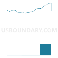
Outline

Summary
| Unique Area Identifier | 612511 |
| Name | Richardson Precinct |
| County | Butler County |
| State | Nebraska |
| Area (square miles) | 36.06 |
| Land Area (square miles) | 35.82 |
| Water Area (square miles) | 0.24 |
| % of Land Area | 99.34 |
| % of Water Area | 0.66 |
| Latitude of the Internal Point | 41.08935180 |
| Longtitude of the Internal Point | -96.96574200 |
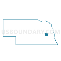
Maps

Graphs
Select a template below for downloading or customizing gragh for Richardson Precinct, Butler County, Nebraska


Neighbors
Neighoring Voting District (by Name) Neighboring Voting District on the Map
- Center Precinct, Butler County, NE
- H Precinct, Seward County, NE
- Oak Creek Precinct, Butler County, NE
- Plum Creek Precinct, Butler County, NE
- Valparaiso Precinct, Saunders County, NE
- West Salt Precinct, Lancaster County, NE
- Weston Precinct, Saunders County, NE
Top 10 Neighboring County Subdivision (by Population) Neighboring County Subdivision on the Map
- Oak Creek township, Saunders County, NE (940)
- Oak Creek township, Butler County, NE (500)
- West Oak precinct, Lancaster County, NE (427)
- Richardson township, Butler County, NE (424)
- Precinct A, Seward County, NE (325)
- Newman township, Saunders County, NE (268)
- Center township, Butler County, NE (200)
- Plum Creek township, Butler County, NE (139)
Top 10 Neighboring Place (by Population) Neighboring Place on the Map
Top 10 Neighboring Unified School District (by Population) Neighboring Unified School District on the Map
- Seward Public Schools, NE (10,431)
- Raymond Central Schools, NE (4,375)
- East Butler Public Schools, NE (1,902)
Top 10 Neighboring State Legislative District Upper Chamber (by Population) Neighboring State Legislative District Upper Chamber on the Map
- State Senate District 21, NE (44,532)
- State Senate District 23, NE (40,859)
- State Senate District 24, NE (34,230)
Top 10 Neighboring 111th Congressional District (by Population) Neighboring 111th Congressional District on the Map
Top 10 Neighboring Census Tract (by Population) Neighboring Census Tract on the Map
- Census Tract 9682, Saunders County, NE (5,485)
- Census Tract 102.02, Lancaster County, NE (4,388)
- Census Tract 9601, Seward County, NE (4,378)
- Census Tract 9678, Butler County, NE (1,958)